Is Salinity Uniform (the same) Throughout the Global Ocean?
Sea surface salinity (SSS) varies because freshwater input & ouput – part of the global hydrologic cycle – varies from place-to-place.
The large scale pattern of evaporation and precipitation is established by earth's atmospheric convection cells. REVIEW: if earth were covered by oceans and not spinning– the atmosphere would move heat between the hot tropics and cold poles in a very simple way. Hot air would rise along the equator, creating a band of low atmospheric pressure. Cold air would sink at the poles, creating regions of high atmospheric pressure.
Remember the 6 convective cells that occur on earth and result in our global wind patterns? There are atmospheric pressure highs at the poles, 30°N and 30°S. It also has atmospheric lows along the equator, 60°N and 60°S. Away from the poles, cloudiness and precipitation (P) dominate bands of low pressure: these latitudes host the world's rainforests. Dryness and evaporation (E) dominate bands of high pressure: these latitudes are home to deserts.
In terms of SSS,
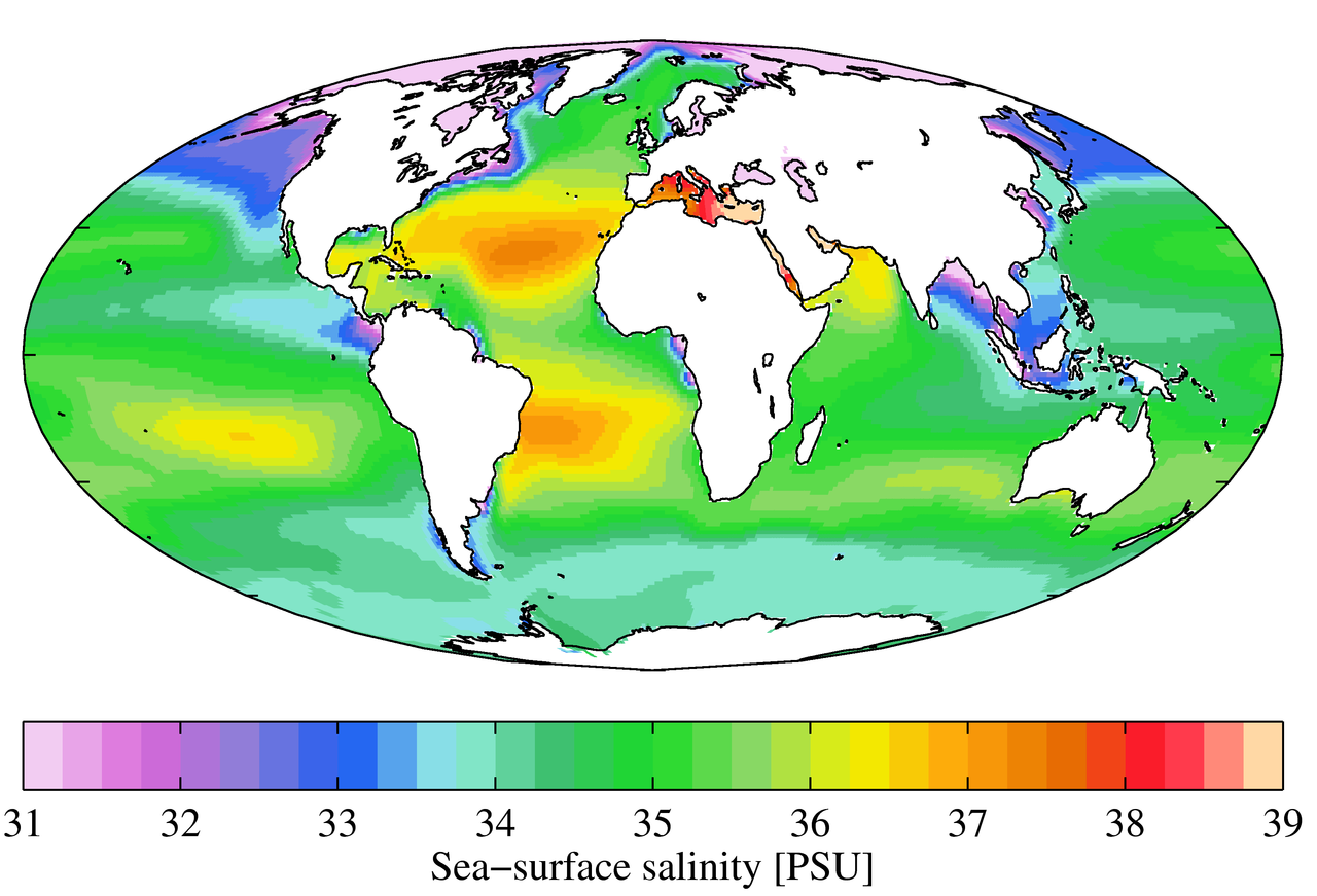
Compare this "six cell" model (left) with the map of global average SSS (right).
Sea surface salinity (SSS) varies because freshwater input & ouput – part of the global hydrologic cycle – varies from place-to-place.
The large scale pattern of evaporation and precipitation is established by earth's atmospheric convection cells. REVIEW: if earth were covered by oceans and not spinning– the atmosphere would move heat between the hot tropics and cold poles in a very simple way. Hot air would rise along the equator, creating a band of low atmospheric pressure. Cold air would sink at the poles, creating regions of high atmospheric pressure.
Remember the 6 convective cells that occur on earth and result in our global wind patterns? There are atmospheric pressure highs at the poles, 30°N and 30°S. It also has atmospheric lows along the equator, 60°N and 60°S. Away from the poles, cloudiness and precipitation (P) dominate bands of low pressure: these latitudes host the world's rainforests. Dryness and evaporation (E) dominate bands of high pressure: these latitudes are home to deserts.
In terms of SSS,
- lower salinity generally occurs where precipitation is greater than evaporation (P>E).
- higher salinity generally occurs where evaporation is greater than precipitation (E>P)
Compare this "six cell" model (left) with the map of global average SSS (right).
- How well do SSS patterns mirror bands of high and low atmospheric pressure?

|
|
There are places on the map that "do not match." What other freshwater inputs/outputs are at work?

Global SSS patterns are governed by geographic differences in the "water budget." Like on continents, some latitudes of the ocean are "rainy" whereas others are arid and "desert-like." In general, latitude zones dominated by precipitation have low SSS and those dominated by high evaporation have high SSS:
- Lowest SSS occurs in temperate latitudes (40 - 50 degrees North and South), near coasts and in equatorial regions.
- Highest SSS occurs at about 25 - 30 degrees North and South latitude, at ocean centers and in inland seas.
