
Fronts
- boundaries separating two masses of air of different densities/temperatures
- the principal cause of meteorological phenomena.
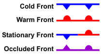
Fronts are classified as to which type of air mass (cold or warm) is replacing the other. For example, a cold front demarcates the leading edge of a cold air mass displacing a warmer air mass. A warm front is the leading edge of a warmer air mass replacing a colder air mass. If the front is essentially not moving (i.e. the air masses are not moving) it is called a stationary front.

A cold front marks the leading edge of a cold air mass displacing a warmer air mass.
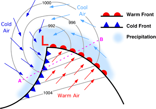
The slope of cold fronts are more steep and air is forced upward more abruptly. This forcing of warm, moist air upward usually leads to a narrow band of showers and thunderstorms along or just ahead of the front, especially if the rising air is unstable. This narrow, yet long line of thunderstorms is called a squall line.
The slope of cold fronts are more steep and air is forced upward more abruptly. This forcing of warm, moist air upward usually leads to a narrow band of showers and thunderstorms along or just ahead of the front, especially if the rising air is unstable. This narrow, yet long line of thunderstorms is called a squall line.

A warm front is the leading edge of a warmer air mass replacing a colder air mass.
Warm fronts typically have a gentle slope so the air rising along the frontal surface is gradual. This usually favors the development of widespread layered or stratus clouds and precipitation along and to the north of the front.
Warm fronts typically have a gentle slope so the air rising along the frontal surface is gradual. This usually favors the development of widespread layered or stratus clouds and precipitation along and to the north of the front.

If the front is essentially not moving (i.e. the air masses are not moving because neither is strong enough to replace the other) it is called a stationary front.
An occluded front is a cold front overtaking a warm front at the center of a mid-latitude cyclone. Cold fronts usually move faster than warm fronts, so they can "catch up" to warm fronts. As the two fronts merge, an occluded front forms. In the occluded front, the cold air undercuts the cooler air mass associated with the warm front, further lifting the already rising warm air.
More ...
Animation of Cold/Warm Fronts with Cloud Types (requires Flash: iPad, copy link and open in a Flash browser such as Puffin)
Presentation: Why You Be Frontin?
More ...
Animation of Cold/Warm Fronts with Cloud Types (requires Flash: iPad, copy link and open in a Flash browser such as Puffin)
Presentation: Why You Be Frontin?
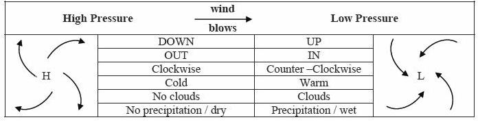
How are Fronts and Pressure Systems Connected?
A midlatitude cyclone is an area of low pressure located between 30 degrees and 60 degrees latitude. Since the continental United States is located in this latitude belt, these cyclones impact the weather in the U.S. High pressure systems are called Anticyclones. Low pressure systems forming in Tropical latitudes are called Tropical Cyclones. These storms may grow to form tropical depressions, tropical storms, and hurricanes.
A midlatitude cyclone is an area of low pressure located between 30 degrees and 60 degrees latitude. Since the continental United States is located in this latitude belt, these cyclones impact the weather in the U.S. High pressure systems are called Anticyclones. Low pressure systems forming in Tropical latitudes are called Tropical Cyclones. These storms may grow to form tropical depressions, tropical storms, and hurricanes.
AntiCyclones vs. Cyclones
- Warm Fronts, not as nice as they sound? (slowly rising warm air --> hazy, rainy weather for days)
- Cold Fronts, not always that cold! (cold fronts are cold in winter, dry in summer,
- Occluded Fronts, the weakening of the storm.
- Why do some fronts slow down and then become stationary?
